 |
| Photo by Peter Silverman |
This trip was all the way back in May of 2010, and was the first of many 'Western' Adventures to come. I’m actually written up and published this trip twice - sadly, for some reason Blogger has taken exception and deleted. Oh well, I’ll have to re-create it as best I can from my feeble memory. This time I’ll make a backup...
This trip started the Memorial Day tradition of making a pilgrimage west to explore the great parks of the U.S. It was life changing, and set the tone for future adventures. It’s still one of my fondest memories - Utah is beautiful country. I’d love to live there someday.

There would be six of us on this trip, flying in separately over the mountains into Salt Lake City, Utah. While I had been through Salt Lake City several times, this would be my first time exploring the state. It took us a while to fully assemble, with flight delays and the like. So we killed some time enjoying the local cuisine, after renting the biggest car we could find (A Suburban with 4 wheel drive). Eventually we were all on the ground, and we took time to raid the local Walmart for supplies. Finally in the early evening, with the Suburban loaded down - we blazed a trail southward to Torrey, a five hour drive away.
Four hours later, with reckless disregard with the speed limit, we made it to the Capitol Reef Inn for the night. The proprietors had kindly left the key under the mat for us, since it was around 1 am and they were all soundly asleep. We got inside and promptly passed out. Having arrived in total darkness the night before, we were greeted with a feast for the eyes as the sun rose. We got in some pics before a hearty breakfast.


We stocked up on some last minute supplies including firewood. We also took a few minutes to more carefully load the Suburban - it's surprising how quickly one fills up when you have 6 guys, their gear, and supplies for 3 days.
Our planned destination was the Fruita campground (also the location of the Capitol Reef Visitor Center). It's the only spot in the park with water, and still has the fruit trees planted by the first settlers. The greenery here was in stark contrast to the surrounding high desert. We had picked this park because it was supposedly less visited by touristy types. But rolling into the campground, we were surrounded by RVs, campers and families with their condo-sized tents. This wasn't what we were after at all, so we quickly reversed course back to the Visitor Center to gather intelligence from the park rangers on alternatives.

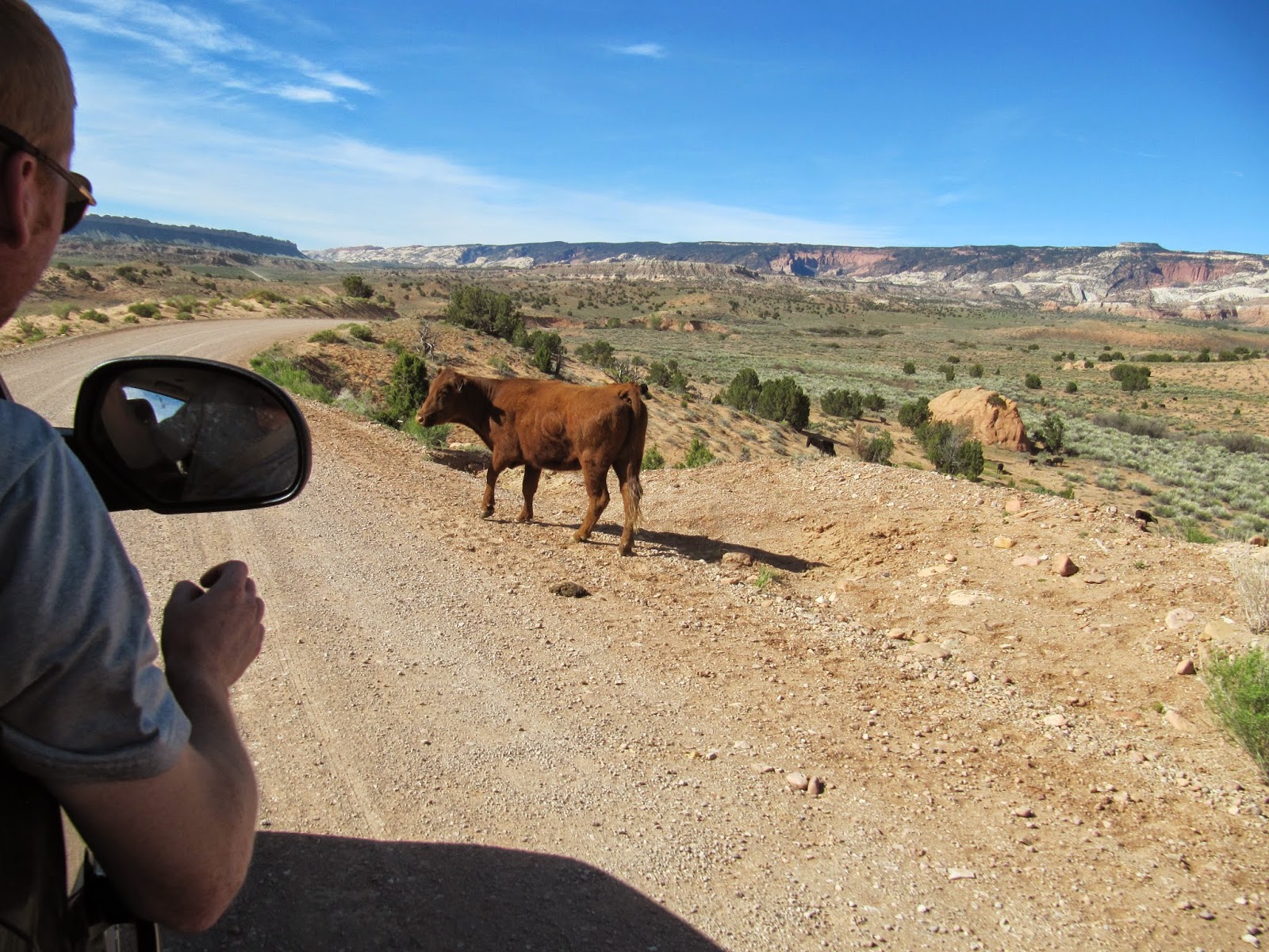
The rangers did not disappoint, and we were soon heading towards an extremely remote, primitive campsite about an 45 minutes away. The majority of this drive was on gravel and dirt roads, along huge empty spreads, ranches, and not much else. We had to dodge the occasional cattle herd as Snow piloted us further into the middle of nowhere. We were driving in what is called the "Water Pocket Fold", a water cut low area between high desert mountains. One thing it did NOT have one drop of - water. The rangers directions were spot on, and we soon had our campsite in the backcountry.
Shortly after establishing camp, we decided to hit some of the trails starting near the visitor center. So we packed day bags and crammed back into the Burban. This would be a relatively quick up and back hike, to the top of the peaks overlooking the visitor center. We topped off water here, as it was literally the only water source we knew of for miles.
This climb showed just how badly out of shape I was. I felt like a slacker next to the group of runners I was with, but did my best to keep up. I guzzled water readily as the sun beat down. Somewhere along this climb, I began to regret bringing my
Maxpedition Kodiak Gearslinger. It's a great bag, and I loved how easy it made water to access while climbing, but the weight of all the water we had to carry soon had the single strap digging into my shoulder. There was nothing for it now, so I soldiered on.
The rock formations we encountered while climbing were fantastic, we had plenty of photo ops as we explored. After checking out a short and crowded side trail where Jake and I took a break to climb the surrounding cliffs, we continued the main climb. We took advantage of shade whenever we found it, there was no hiding from the sun out here for long!
 |
| Pathfinder shows us the way. |
The views were even more breathtaking as the climbing became even harder. Everyone felt it now. We stopped for many photo breaks along the way. Dehydration was definitely kicking in at this point. We had left the casual day hikers behind, This was certainly not the 'sandal path' as the first part had been. But the rewards were worth it. The lens of my
Canon Powershot strained to absorb a fraction of the view.
Finally we reached the grand vista for the day. We hung out for a bit here getting more pictures, climbing, and trying not to get ripped from the rock by the 60mph winds.
At this point, being out of water, we had no choice but to halt our climb and descend. We made a fast pace back the way we had come. When we reached the stream at the bottom leading back to Visitor Center, we soaked our battered feet. After another water fill up, it was back to our campsite for a fire-ring dinner. Apparently there had been a bit of a dust storm while we were gone - all our tents were covered and filled with a fine red layer of the stuff. There was no escaping it out here.
Our day finished off with a spectacular sunset.
The next day, we were up and off, pushing further into the backcountry. We planned to tackle the Upper Muley Twist, a 9 mile circuit hike. Several backcountry roads, steep switchbacks, and a dried river bed later - we arrived at the trailhead. Some other hikers recommended we hike the loop counter clockwise, which would mean getting the steep climbing done first, and every increasing wide views of the surrounding canyons.
The views did not disappoint at all! To our right, and east, we had the Water Pocket Fold. To the west, a deep canyon that we would eventually descend into. We climbed steadily along the ridgeline, which was sometimes no more than a knifes edge. There were a few places where you absolutely did NOT want to put a foot wrong.
After more photo ops, and lunch, we eventually made the turn and started down the canyon. There was some shade, and it was a welcome relief. We had a few tricky sections to negotiate, but most of this leg was a pleasant cooldown.
We made it back to the ‘burban in one piece, and managed to reverse down the creek bed unscathed - despite often scraping over boulders along the way. We descended back down into the Water Pocket fold with the transmission firmly locked in first gear and a foot on the brake.
The next day, we squeeze in one more day hike before heading back north to Salt Lake. I think it was roughly a four mile loop - the name escapes me now. Sadly, I didn’t run a GPS back then! But we were treated to another high view overlooking Fruta Valley and the Visitor Center.
Sun-baked and tired, we regretfully left the gorgeous canyonland behind us, and returned to civilization. I couldn’t wait to return!
 |
| Photo by Peter Silverman |


No comments:
Post a Comment