Friday, November 14, 2014

Four State Challenge

In a fit of madness, I signed up for DCUL's Four State Challenge this last October. For those unfamiliar, this is a challenge some AT thru-hikers undertake.

Essentially, you wake up super early at the Virginia border (or the PA border if you are headed southbound), cross into WV, and then plow through 40 plus miles of the AT through Maryland until you get to the Pennsylvania border at Pen Mar Park. Total mileage, 44ish. In one day.

DCUL'S way of doing is to backpack in to to the Harper's Ferry area, and do it as a section hike. Not a day hike or trail run. We camp out on both ends and have no support. Last year was the first year for this one, but I missed it for another trip. Sadly, I wasn't in the shape I was last year - but I was still optimistic I could finish.

This was a proper challenge, testing mental and physical endurance. I was mentally prepared to blast it out, but had no idea what would happen to my body past 30 miles - uncharted territory.

As is typical, we arrived in the rain, and had a cold, dark, foggy walk to Loudan Heights from Harpers Ferry.  We had 11 crazy backpackers attempted the challenge this year.  Once over the Virginia line, we made camp, then had a celebratory cake for U-turn's birthday.  We all turned in around 9:30ish.  I had a wet night, my new SoloMidXL needed some seem sealing!  I've been to used to Cuben shelters and forgot about properly prepping the sil nylon seams.  I didn't get much sleep, and was up and breaking camp at 2:30 to get on the trail at 3:00am on the dot.

After separating from the pack just after Harper's Ferry, EZBake, Faceplant, Beastmode and I blasted along the canal, and then Dave led us up the first climb in the rolling fog. After taking advantage of a rest stop, the sun was up and I stretched my legs - Kylie and Joffrey quickly caught up. We would hike together, swapping the lead until the very end - walking between a 3.5 and 4 mph pace. We banged out 20 miles by 9am, then took a long brunch break at the Washington Monument. Dave caught us up and continued on. We leaped frogged him again, then crushed the miles to I-70 and the sign-in sheet at Jen's car just before 11:30. We ran into Dave again just after this, he realized he had missed the turn for the parking lot and doubled back. Somewhere around Annapolis rocks we encountered a lethargic copperhead snake attempting to sun himself.

We all still felt pretty good at this point - though it seemed like I was crawling up the hills. I blamed it on crappy sleep, or maybe I wasn't quite over the cold I brought back from Arizona. Nonetheless, we knocked about the next 10 miles to Dave's car in no time - where we had a good laugh at his pain rating sheet! After a final fuel-up break, we pressed on. We still had a fast pace going. Just after Raven Rocks, I had a dizzy spell and stopped for several minutes to regroup. This is the second time in my life I remember having what I assume is a blood sugar crash.  Snickers to the rescue! Kylie and Joffrey pressed on.

The PenMar rocks made me want to scream - I've never felt unsure of my legs when walking over rocks before! They weren't responding normally, and extra concentration was needed. But after that I got my wind back and jogged the rest of the way, reaching the end just a couple minutes after Faceplant and Beastmode. Miles was a sight for sore eyes, and the pizza was everything I hoped it would be.

In the end, I finished just a couple minutes behind Beast Mode and Faceplant, who set a new time to beat at 14 hours 30 minutes.

With the temperature dropping, we retreated to a nearby camping spot.  I was asleep with seconds of my head hitting my pillow.

Grand Canyon Rim to Rim to Rim

In late September, I decided to return the Grand Canyon.  This time, I would dispense with the lengthy shuttle drive, and instead simple do a grand out and back - backpacking from the south rim, to the north, then back again over four days.  Things...didn't quite go as planned.

I was joined by a tough group of backpackers, including Joan!  Her second backpacking trip!

You can check out the full write up over at DCUL Backpacking!  Sorry, it's a long one :)


Thursday, October 2, 2014

The Bob Marshall Wilderness, Montana

In early September, I led a group into The Bob Marshall Wilderness (just "The Bob" to Montana locals).  You can check out the write up over at DCUL Backpacking.


Friday, August 8, 2014

So long Citimortage, it's been real...


It's done at last!  A week ago I sent in my last payment.  Finally, my house is really 'mine', not quite 10 years after purchasing it on Oct 1, 2004.  It's been a tough slog.  I was lucky to have a lot of help rehabbing it (calling it a fixer-upper would have been kind).  I'm very grateful for Chris and Jackie Billing selling it too me in the first place.  It was a complex situation back then, but they had my back and I'll never forget it.

What would eventually be my office, a few weeks into the wall-to-wall gut out.

I don't want to sully this blog with nerdy financial talk - but if you are curious how I did it (no, I don't make that much money), I started a new one: Will's Money Tips, where I'll talk about financial tips and info.

I have aspirations of writing a book someday on the subject.  Mostly because I'm saddened by the general lack of knowledge and huge misconceptions about finance, mortgages, etc. out there (seriously, why isn't this stuff taught in high school?).  There are so money books on investments - but that only helps if, you know, you have money to invest...

To be honest, I'll probably never set aside enough time to do it...but maybe someday.  Hopefully my experiences will help someone.

Friday, July 11, 2014

Adirondacks Great Traverse

Last weekend for 4th of July I tackled another DCUL Backpacking trip to New York's Adirondacks.  This would be my second time in the High Peaks region.  This time we would tackle the Great Traverse.  In typical DCUL style, we had to make it more difficult of course.  Jimmy's (GQ) and Karan's (BA) plan included 17 peaks!  Cake right?


I met Jimmy, Karan, Kylie, Jess, and Upsana at the Greenbelt metro and we started our long haul north. We scooped up Hau from Delaware House - and would meet John who had driven up a day earlier from PA at the ending trail head.  Kylie is from NY, and her parents had graciously offered to let us crash at their house.  We rolled in slightly before midnight, and got in a quick nap.  I slept maybe an hour before getting up at 4:30.  We still had an hour to go, and worried about getting parking at the Adirondack Loj.  We also wanted breakfast!

Groggily we rolled out, hitting the Noon Mark Diner where we met John and slammed down a fast meal.  We made the quick 30 minute drive to the Loj trailhead parking lot, happily finding plenty of room.  We wasted no time in hitting the trail head, climbing gently towards the first intersection where we hung a right and started the real climbing.  We made it to the turn for Wright in short order. Here, in typical ADK fashion, the trail becomes more boulder than path - and turns steeply upward.  All the recent rain insured the rocks would be slippery, and the spaces in between muddy.  My Asics Gel Scouts held on well, despite being just trail runners.


Soon we were in alpine territory, above the treeline, and completely clouded in.  I wasn't feeling very strong, running on no sleep and no exercise since the Foot Hills Trail almost a month ago!  We all ground our way to the top.  We snapped some picks, but with not much to see and high winds we soon reversed course and provided with the rest of the peak bagging for the day.  Algonquin, Boundary, and Iroquois all went down in order.  The cloud cover persisted, and the climbs remained consistently tough - full of scrambles and tricky climbs.  The summits were still glorious, despite the white out.


With the range defeated, we descended southeast towards Lake Colden.  At this point, instead of heading straight to the shelters at Uphill or Feldspar, we decided the trip wasn't difficult enough - and started climbing northeast to bag Mount Colden.  What a bear this one was!  My tank was empty, and I trudged up the treacherous climb at a snails pace.  Everyone struggled here, except for Karan who is simply a beast, and Kylie who matched him step for step!  Exhausted, we all eventually made it to the top.  We were rewarded with our first clear summit as the clouds lifted.


With our peaks bagged for the day, we made the descent down to Feldspar and wedged ourselves into the available camp space - which wasn't much!  We made it just before dark, and had a quick dinner in the fading light before passing out for the night.

We were up and back on the trail around 7, with many more peaks in our sights.  We passed some more familiar paths, albeit free from snow!    The weather was perfect and clear.  We snapped some pics at the headwaters to the Hudson before climbing Marcy.


This would be my second summit of Marcy, and it was a nice change to have clear skies!  The climb was no less difficult, but it was a pleasure to be able to hang out and enjoy the views without fear of freezing to death quickly.  We ran into another ADK steward here, and numerous day hikers.  For some reason, few people besides us seemed to be backpacking over every summit!  Spirits were high, and we hoped for an earlier finish today.  Pyramid peak was nixed from the plan, and we headed for the haystacks.


The challenging rock scrambles continued - we could rarely take more than a few steps it seemed without having to make monster steps or pulling ourselves up with whatever hand holds we could find.  Progress was slow!  Nevertheless, we crushed Little Haystack and Mount Haystack in short order.


From there, we retraced our steps to continue our summit chase.  Another steep descent, followed by yet another scrambling climb brought us to Basin Mountain.  No part of this trail was easy, and the challenges continued.  Often when descending, it was necessary to turn yourself uphill and down climb hand over hand.  Patches of slick rock added to the danger!

Everyone made it more or less in one piece, though there were occasional slips and slides.  The scrapes and scratches were rapidly accumulating.

We had gorgeous views of the ranges already climbed - I kept thinking to myself it seemed impossible that we had been up and down so many mountains!


One of the more interesting challenges was yet ahead - the climb up to Saddleback.  Rock climbing experience absolutely helped here - it would be a test of nerves.  Still hauling our packs, with 50 mph windows rocking us, pulled ourselves up the rock face.  This was the first time I was worried about the group making it up We decided to wait and regroup to make sure everyone summitted in one piece.

It took some time, but we all made it without being swept off the face by the wind.


We regrouped atop Saddleback, then continued along the ridge.  I took a hard tumble on some slick rock going down the backside, but no harm no foul.  The descent wasn't any harder then the previous ones had been.  Up next: Gothics!  The climb up to the alpine section wasn't terrible.  Inexplicably, there were cables here (but not on Saddleback?!).  They weren't really required as the rock was dry, but I made use anyway and gave my legs a break.


Behind us was a wide and spectacular view of what we had already climbed and the lakes below.  Sweaty and tired, we again waited at the top for everyone to regroup.  Our plan was to get to Wolf Jaws shelter for the night.  This was the last time we regrouped, as we decided to hurry on before we lost all daylight.  Kylie and I took the lead and quickly climbed the next peak - Armstrong.  Less glorious, it was still a cool summit with one side open to the valley.  We pushed on quickly to Upper Wolfjaw, which has a very small summit just barely peaking above the trees.


We had a rolling regroup here, before Kylie and I again pushed on to Wolf Jaws shelter.  I was finally feeling good, and was able to get up to cruising speed in this rolling terrain.  There were still challenges, but only 10 per mile instead of 100!  The Nat Geo TI map showed the shelter a little over .6 miles.  Kylie's showed it at about .9.  It turned out to be morel like 1.4.  We made it with the last of the light.  The shelter was full, and campsite half full.  Everyone else rolled in by headlamp, and we all scattered around the site wherever we could.

It took me a full 45 minutes to hang my shelter and tarp!  I was not feeling myself, and normally simple tasks were proving extremely difficult.  Kylie was amused that she had her shelter up, walked back to get water, and eaten before I sat down to start cooking!  I later learned Karan wasn't feeling so hot either.  The day had been hot and hard, and we were all still short on sleep.  We turned in as soon as dinner was done, stashing our bear cans away from camp.

I crawled out of my hammock at 7, feeling much better (though I could have slept longer).  We broke camp quickly, anxious to push out the last 7 miles.  We doubled back south, climbing back to the ridge, then hanging a left towards Lower Wolf Jaw Mtn.  We spread out again, tackling the ever present rock challenges independently for the most part.  Lower Wolfjaw wasn't terribly glorious, with just a small boulder to stand on.  But it was a good spot to cool down from the brutal last .5 mile climb straight up.  I chatted for a minute with a day hiker headed back the way we had come.  I can't remember seeing any backpackers since Marcy the day before.  We didn't tarry long, and blasted on, towards Hedgehog.  We were actually moving so fast, none of us realized we had summitted until half a mile past the peak.  It seemed to be completely tree'd in, with no obvious herd path to any views.  
We cruised on.  John, Jimmy and I took the lead - we had the keys and wanted to get the shuttle reversed to save everyone else from waiting too terribly long.  Jimmy called back to Karan - "Take care of the women!".  He waited at the intersection for everyone to catch up.

We crushed the last couple miles in no time.  It's amazing as you get close to the trailhead, how smooth and easy the trail becomes!  We passed a couple climbing up to Rooster Comb, which we had decided to nix for the sake of saving time.  After chatting about what we had just done, they were in complete disbelief.  Apparently our route is rarely tackled - and maybe never backpacked?

We all reunited at the crowded Noon Mark Diner, but decided on lunch at the Inn just up the street.  Good choice!  The food was great (if pricier than the NMD).  After stuffing our faces, and some group photos - we started the long and brutal drive home in holiday Sunday traffic.

Reflecting back, this was easily one of the hardest hikes I have done.  I'm sure starting off with good sleep and being in better shape would have helped - but the climbs and descents were tough, and take their toll no matter what I think.  It felt like a a great accomplishment, that it seems few people (if any?) attempt.  Even the 'standard' Great Travese is no joke.  It's some tough trail to cover.

Photo by Jimmy Jin
Check out Jimmy's Trip report over at DCUL Backpacking.


Saturday, June 28, 2014

Massanutten South Loop - April 2014


After regretfully cutting short my Sufferfest attempt in march, I vowed to return and achieve redemption.  Time was going to be limited however, so co-conspirators Alison and Dan joined me in whipping up a trip to explore the southern loop of the Massanutten chain.  The trip was a great success!  You can see the write up over at DCUL Backpacking.

Capitol Reef Expedition

Photo by Peter Silverman

This trip was all the way back in May of 2010, and was the first of many 'Western' Adventures to come. I’m actually written up and published this trip twice - sadly, for some reason Blogger has taken exception and deleted. Oh well, I’ll have to re-create it as best I can from my feeble memory. This time I’ll make a backup...

This trip started the Memorial Day tradition of making a pilgrimage west to explore the great parks of the U.S. It was life changing, and set the tone for future adventures. It’s still one of my fondest memories - Utah is beautiful country. I’d love to live there someday.


There would be six of us on this trip, flying in separately over the mountains into Salt Lake City, Utah. While I had been through Salt Lake City several times, this would be my first time exploring the state. It took us a while to fully assemble, with flight delays and the like. So we killed some time enjoying the local cuisine, after renting the biggest car we could find (A Suburban with 4 wheel drive). Eventually we were all on the ground, and we took time to raid the local Walmart for supplies. Finally in the early evening, with the Suburban loaded down - we blazed a trail southward to Torrey, a five hour drive away.

Four hours later, with reckless disregard with the speed limit, we made it to the Capitol Reef Inn for the night. The proprietors had kindly left the key under the mat for us, since it was around 1 am and they were all soundly asleep. We got inside and promptly passed out. Having arrived in total darkness the night before, we were greeted with a feast for the eyes as the sun rose. We got in some pics before a hearty breakfast.


We stocked up on some last minute supplies including firewood. We also took a few minutes to more carefully load the Suburban - it's surprising how quickly one fills up when you have 6 guys, their gear, and supplies for 3 days.

Our planned destination was the Fruita campground (also the location of the Capitol Reef Visitor Center). It's the only spot in the park with water, and still has the fruit trees planted by the first settlers. The greenery here was in stark contrast to the surrounding high desert. We had picked this park because it was supposedly less visited by touristy types. But rolling into the campground, we were surrounded by RVs, campers and families with their condo-sized tents. This wasn't what we were after at all, so we quickly reversed course back to the Visitor Center to gather intelligence from the park rangers on alternatives.


The rangers did not disappoint, and we were soon heading towards an extremely remote, primitive campsite about an 45 minutes away. The majority of this drive was on gravel and dirt roads, along huge empty spreads, ranches, and not much else. We had to dodge the occasional cattle herd as Snow piloted us further into the middle of nowhere. We were driving in what is called the "Water Pocket Fold", a water cut low area between high desert mountains. One thing it did NOT have one drop of - water. The rangers directions were spot on, and we soon had our campsite in the backcountry.


Shortly after establishing camp, we decided to hit some of the trails starting near the visitor center. So we packed day bags and crammed back into the Burban. This would be a relatively quick up and back hike, to the top of the peaks overlooking the visitor center. We topped off water here, as it was literally the only water source we knew of for miles.


This climb showed just how badly out of shape I was. I felt like a slacker next to the group of runners I was with, but did my best to keep up. I guzzled water readily as the sun beat down. Somewhere along this climb, I began to regret bringing my Maxpedition Kodiak Gearslinger. It's a great bag, and I loved how easy it made water to access while climbing, but the weight of all the water we had to carry soon had the single strap digging into my shoulder. There was nothing for it now, so I soldiered on.


The rock formations we encountered while climbing were fantastic, we had plenty of photo ops as we explored. After checking out a short and crowded side trail where Jake and I took a break to climb the surrounding cliffs, we continued the main climb. We took advantage of shade whenever we found it, there was no hiding from the sun out here for long!

Pathfinder shows us the way.

The views were even more breathtaking as the climbing became even harder. Everyone felt it now. We stopped for many photo breaks along the way. Dehydration was definitely kicking in at this point. We had left the casual day hikers behind, This was certainly not the 'sandal path' as the first part had been. But the rewards were worth it. The lens of my Canon Powershot strained to absorb a fraction of the view.


Finally we reached the grand vista for the day. We hung out for a bit here getting more pictures, climbing, and trying not to get ripped from the rock by the 60mph winds.


At this point, being out of water, we had no choice but to halt our climb and descend. We made a fast pace back the way we had come. When we reached the stream at the bottom leading back to Visitor Center, we soaked our battered feet. After another water fill up, it was back to our campsite for a fire-ring dinner. Apparently there had been a bit of a dust storm while we were gone - all our tents were covered and filled with a fine red layer of the stuff. There was no escaping it out here.


Our day finished off with a spectacular sunset.


The next day, we were up and off, pushing further into the backcountry. We planned to tackle the Upper Muley Twist, a 9 mile circuit hike. Several backcountry roads, steep switchbacks, and a dried river bed later - we arrived at the trailhead. Some other hikers recommended we hike the loop counter clockwise, which would mean getting the steep climbing done first, and every increasing wide views of the surrounding canyons.


The views did not disappoint at all! To our right, and east, we had the Water Pocket Fold. To the west, a deep canyon that we would eventually descend into. We climbed steadily along the ridgeline, which was sometimes no more than a knifes edge. There were a few places where you absolutely did NOT want to put a foot wrong.


After more photo ops, and lunch, we eventually made the turn and started down the canyon. There was some shade, and it was a welcome relief. We had a few tricky sections to negotiate, but most of this leg was a pleasant cooldown.


We made it back to the ‘burban in one piece, and managed to reverse down the creek bed unscathed - despite often scraping over boulders along the way. We descended back down into the Water Pocket fold with the transmission firmly locked in first gear and a foot on the brake.


The next day, we squeeze in one more day hike before heading back north to Salt Lake. I think it was roughly a four mile loop - the name escapes me now. Sadly, I didn’t run a GPS back then! But we were treated to another high view overlooking Fruta Valley and the Visitor Center.


Sun-baked and tired, we regretfully left the gorgeous canyonland behind us, and returned to civilization. I couldn’t wait to return!

Photo by Peter Silverman

Thursday, June 26, 2014

WFA Certification!

At last I managed to get registered for a WFA course before it filled up!  This one was hosted by REI at Bailey's Crossing but NOLS (National Outdoor Leadership School) WMI (Wilderness Medicine Institute).  For those that don't know, WFA is simply Wilderness First Aid - very similar to your standard front country First Aid course, but with additional instruction for backcountry support.  There is also the Wilderness First Responder (WFR or Woofer) course, a much longer and in depth version.

The certification requires 16 hours of classroom time, and covers all the basics of scene evaluation, patient evaluation, treatment and evacuation decisions.  I found a lot of overlap with previous first aid and CPR courses I've had, and having my knowledge refreshed was very helpful.  There was also a lot of new info on treatment.  In front country (urban) first aid, you basically do only the most cursory of evaluations and treatment and then wait for the paramedics.  In a wilderness setting, you might be all your patient has for hours, or days.  The training and treatment we learned reflected that.

I found the course on a whole informative and fun.  The instructors Ted and Becca were a great resource.  Ted had obviously been around the block a few times, and Becca was an experienced Ski Patrol medic - both had plenty of stories to share about injuries and mis-adventure!  Examples of wilderness injuries were passed around.  I was particularly amused by the frost bite pictures.  Turns out the mild frost nip I had this past winter was actually partial thickness frostbite.  Whoops!

Head wound from an errant bear line toss!

Other simply skills were learned like properly taking a sprained or strained ankle to allow supported movement I most certainly could have used a few times.  I'm positive I'll need this particular skill again!  We also practiced with improvised splints.  We discovered my Therarest Z-seat pad made an excellent arm splint at only 2 ounces, and I learned a cool splint 'stitching' technique using climbing webbing.


The class was a mix of instruction and play-acting as we took turns being patients and medics.  Moulage blood and makeup was used liberally.  I found I was especially good at playing the totally unresponsive victim. The class was definitely very hands on!

I liked the instruction on using supplies that the 'pros' use.  Suture strips, transparent badges, 2nd skin burn pads and the like.  They all make wound care and dressing so much easier.  I'm looking forward to the next time someone really slices themselves up!  Sadly, this will probably be myself.  Considering the increasing rate at which I've been injuring myself, it's only a matter of time.


Friday, June 20, 2014

A good year of backpacking

Just over a year ago in April, my friend Peter (co-conspirator on many adventures) invited me along on a trip with a meetup group called DCUL Backpacking.  It was a single overnight from Saturday to Sunday, walking a 20 mile loop starting in Caledonia State park.  He had told me stories about how quickly this group moved, so I was a bit dubious about my ability to keep up.  We would do even split of 10 miles, which didn't seem bad at all.  I had certainly done more mileage and longer trips.  But I knew the pace was going to be fast and I hadn't been backpacking in quite some time.  I was in relatively good shape otherwise I figured, having recently done well in my first sprint triathlon.  So why not?

It had been a few years since I had gotten back into backpacking, and coincidentally had starting working on going 'Ultra-light' - the theme behind this backpack group (besides high mileage!).  So this seemed like a great opportunity to see how the pros did it - since I'd been basically figuring it out as I went along.  The group (and this trip's) leader Michael Martin had an enviable amount of backpacking mileage under his belt, and was very gracious in welcoming newcomers.

The trip was a great success!  Though I spent a slightly chilled night having underestimated my insulation (not the first time, or worst!).  My fears about not keeping up were unfounded - I guess backpacking with a bunch of cross-country runners for the past couple of years had it's benefits!  I was totally wiped after the trip however.  I can't remember what my total pack weight was, but I'm sure it was still grossly not ultra-light at this point for a one-nighter.  I got home, laid down on the floor and took a good nap while my dogs went nuts.

The year that followed was inspiring and humbling.  I learned a tremendous amount from Michael and others in DCUL - all those little tips and tricks no one even thinks about.  I was introduced to a myriad of cottage shops that catered to the ultra-light backpacking world.  Since the Caledonia trip, I have changed ALL my gear.  I stuck with hammocking, and slowly refined and perfected my system.  No more chilly nights!  I'm now happily sitting at a sub-8 pound base weight for 3 season gear.

Quite surprisingly to myself, I quickly worked up to doing a 20 mile day - something that had seemed utterly ludicrous to me a year ago.  I've even hit 30 a couple of times (if just barely).  My definition of a 'short' trip has been drastically altered forever, much to Joan's chagrin.  I hiked just under 600 miles and spent around two dozen nights outside.  I'm no Michael Martin - but I'm pretty happy with that mileage.  My personal record for longest trip was beaten several times - though sadly I fell short of completing the Massanutten Sufferfest.  Next year....

I went on two long point to point trips that raised my personal bar.  The first was the Loyalsock Trail, an amazing 60 mile trek through PA on which I earned my trail name, Savage.  I'm not sure who gets credit, but I think it was a collaboration between Alison, Dan, and John (who led the trip) after witnessing my occasional disdain for modern convention and technology such as footwear.  

The second long point to point was just last month along the Foothills Trail in SC.  The trail is 77ish miles, though we walked just over 85 visiting various waterfalls.  It was an amazing five day trip, and one I never would have attempted a year ago (or taken three times as long to do).  It was great to finally feel like I had my system dialed in.  Though of course there are always tweaks and improvements to be made, and more to learn.

There were other notable changes, like ditching boots for light weight trail runners.  My feet are so tired of blisters!  There is no going back.  I learned to cross-country ski (not well, despite excellent tutelage).  I also topped my coldest night outside on the Hammersley Wild trip, also to PA.  Our best estimate puts the low end at -5F.  All that work on my hammocking system for winter had really paid off!

Sometime in the first few months MM had the crazy idea to make me a trip leader.  Though I was dubious about leading new people into the woods, I eventually warmed to the idea.  Up until now I had only put together trips for myself or close friends - people who I knew would roll with my crazy plans without complaint.  So naturally for my first official DCUL trip, I plan a major undertaking out west to Zion National Park!  What could possibly go wrong?

Fortunately, nothing did.  And I haven't managed to kill anyone on subsequent trips yet.  Hopefully a trend that continues.  I've continued to be humbled by my fellow adventures, both by their knowledge and toughness. I'm grateful for Peter introducing me to DCUL, for the new friends I've made there, and especially for everyone at DCUL putting up with my crazy self.  The adventure continues!


Friday, April 18, 2014

Zion National Park - Canyon Madness


This was an all-out adventure with three incredibly tough and hardcore hikers. Mind-blowing views were enjoyed, extreme weather swings and frigid waters were endured.  We logged 60 miles in Zion's canyons, mountains, and rivers over six days - managing to hit all Zion’s highlights in one epic trip.

Peter (Fiber One, aka Pathfinder, aka Towpath), Alison (Cover Girl), Jake (The Red Fox), and I met at BWI airport at sunrise Wednesday morning for the long flight to Vegas. We flew directly over the Grand Canyon but unfortunately were on the wrong side of the plane to see it. We did have a good view of Hoover Dam. Once on the ground we picked up two rental SUVs then gorged ourselves on an absurdly oversized lunch at the Hash House a Go Go. Slightly sick to our stomachs we rolled up I-15 at high speed leaving Vegas in the dust.

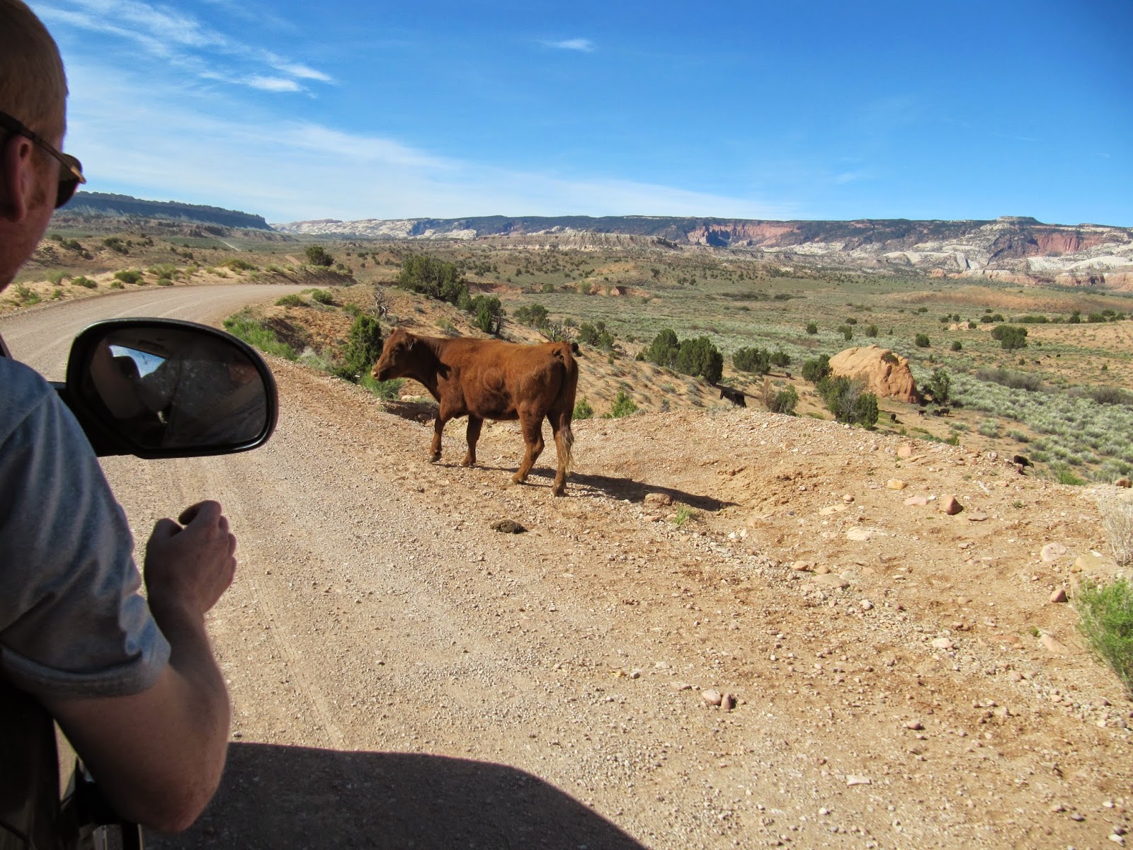
We made the 3 hour drive to Zion in a little over 2 hours, stopping only for provisions at Walmart (including about 30 gallons of water). Entering the park, we encountered a guy selling his annual National Parks pass for cheap - only to discover they aren't transferable. But with a bit of larceny Alison bluffed her way passed the gate. After picking up our back country permit at the Visitor Center, we left one car behind as a shuttle and continued through the park to the East Rim Trailhead. Knowing the only water source would be dry our packs were loaded down with 5 or more liters of water.


East Rim to Observation Point

We climbed slowly but steadily on surprisingly sandy trails surrounded by towering white and red sandstone mountains. The incredible vistas faded into a clear starry sky as we switched on our headlamps. We passed Stave Springs at mile 6 and started looking for a place to camp. Peter found some open ground and we gladly ended our day around 9pm MT. After putting up our shelters we rehydrated our meals, foregoing a campfire (sadly fires are not permitted in the Zion backcountry). We bedded down to avoid the gusting desert winds. Temps were in the mid-40’s but dipped even lower when the wind picked up.


The next morning we awoke to the amazing Zion landscape we had missed hiking through the night. Continuing our trek Northeast on the East Rim trail, we began descending a winding route through the canyon. The trail was well worn, becoming rocky as the landscape changed and we left the scattered forests behind. Often we traveled over bare rock where the path was marked only by cairns. Eventually the ascent to Observation point began. The temperature climbed into the 80's as we tackled the switchbacks. We encountered other hikers making the much shorter day hike up from the Weeping Rock Trailhead, and gleaned some valuable intel for our other hikes. Alison and I reached the top a few minutes behind Jake and Peter, where we were greeted by an awesome view of the canyon floor - and by fearless chipmunks attempting to score a meal. We took a lunch and photo break while looking down on the valley below, and Angels Landing (the next days destination) to the west.

We retraced our steps down from Observation point as even more day hikers arrived, and descended to the intersection with Weeping Rock Trail. Hanging a right, we entered a narrow slot canyon and found a still pool of water were we took another photo and video break before moving on. We passed on stopping at the Emerald Pools as this lower section of trail became lousy with touristy folk and instead set a fast pace down

the steep switchbacks to the trailhead, ending our hike at around 16 miles. After a much needed restroom break we hopped on the free canyon shuttle back to the car stashed at the visitor center.

With our first hike behind us, Peter and I retrieved the other rental while Alison and Jake refilled our water jugs. Again leaving one car behind for the next day's return shuttle, we headed south in the other rental out of the park to Springdale. Stopping for lunch and milkshakes at a place called Blondies', Peter once again amazed us with the size of his appetite.

Despising any campgrounds populated with RVs, I elected to avoid the crowded valley sites. So with the light getting low, we blazed a trail southwest then turned north onto the curvy Kolob Reservoir road towards Lava Point. Our luck held and there was still a site open at the free primitive campground there. We made camp as dusk settled in and the temperature plummeted. Tonight we enjoyed a roaring fire with dinner before turning in.


West Rim to Angels Landing


We rose well before dawn and hit the trail around 5:30. Picking up Barney’s Trail right from the campground, we descended quickly to a gravelly road and headed East towards the West Rim Trailhead. Hiking by headlamp for over an hour, the sun finally rose giving us the most incredible views yet of Zion. We stopped often for photos of the landscape that seemed like it was pulled right from a desktop wallpaper - too beautiful to be real.


The trail dipped, rose, and weaved through ever changing scenery. We even saw some Fall colors in the tree leaves here for the first time in the park. We took a slight shortcut via the Telephone Canyon Trail in the hopes of beating the massive throngs of tourist other hikers had told us to expect. Once it connected back with the West Rim Trail we descended on solid rock switchbacks, finding a dead deer that must have fallen from high above. Next came the climb to connect to The Grotto Trail which would get us to Angels Landing.

At the intersection were some pit toilets, and numerous day hikers milling about. Some people elected to leave their packs here for the climb, but we deemed that far too easy and began the climb immediately after putting away our hiking poles. The route followed a series of chains and rails along a single-file knife edge that climbed ever upward. Often we needed to haul ourselves up by the chains or scramble up rippled rock faces. Occasionally we stopped to allow hikers descending to go by, and we passed many people that needed breaks before they could continue up. Just when it seemed the climb would never end, the path leveled off and we were at the top! Peter ran into a friend here of all places and chatted while Alison, Jake and I had a snack and enjoyed the most impressive view yet. More chipmunks extorted tolls from everyone they could.


The climb down proved not as difficult as we feared, and we blazed a trail down the Grotto Trail. Many times during the steep descent we passed people taking breaks, and wondered how they would make it to the top before nightfall. We finished out our 18 mile day at a chilly trail-side river pool. Jake and Peter enjoyed a brief swim while Alison and I were content to cool our feet.

Another shuttle ride got us back to our car, and we again over-indulged on some food at Blondie’s before picking up some gear for the Narrows hike at Zion Adventures. Peter, ever prudent and convinced we were in for Frozen Hell went for a full dry suit and canyoneering boots. Alison and Jake went for dry-pants and neoprene socks to go with their Keens. I decided the dry pants made me look fat so I left them behind in favor of my hiking shorts and neoprene socks to go with my Merrel’s.

We rolled back to Lava Point Campground for the night to pack our gear, have dinner and enjoy a fire before gladly passing out for the night.


The Narrows


Leaving camp at 5am, we drove back to Zion Adventures to rendezvous with our shuttle and driver John who proved to be quite a character and font of information. After an entertaining high speed drive and many stories he dropped us off at Chamberlain’s Ranch, whose gracious owners allow hikers access to the top of the Narrows via their property. The air was quite chilly, close to freezing even though the sun was up by now. A couple dozen people in total were dropped off, while they lined up for the bathroom we hit the trail. There was a quick stream crossing during which I nearly face planted in the mud, then a couple miles of walking on gravel roads and dirt trails to the Virgin River. Before the first crossing we changed out of our cold weather layers and got ready to get wet.

For 10 miles we alternated between slogging through cold water, crossing streams and walking on short trails. The river was usually ankle deep but sometimes close to waist deep. We all had a chill in our bones until a couple hours later when the sun finally touched the canyon floor. Stopping for a quick snack in a sunny spot, Jake ditched the dry pants which were killing his ankles and would finish the rest of the hike in his shorts.

When we hit the first major tributary Big Bend, we had a quick stop to filter some water (we had been warned repeatedly not to drink from the Virgin River until this point). We arrived at our reserved campsite #9 around 2pm and shed our wet clothes. Peter pitched his Trailstar (the only shelter we brought along) and lounged around camp.

As luck would have it Site #9 was 5 star, the best of the campsites we saw. No fires are permitted in the Narrows, though it was obvious the site had seen many. I won’t confirm or deny that we had a glorious campfire that night - but there were massive piles of driftwood..and we had loads of time to kill! Jake and I cowboy camped while Alison and Peter enjoyed the extra warmth under the Trailstar.


With just 6 miles to go, we took our time breaking camp hitting the river once more just before 9am. The part of the trail was more enjoyable, challenging, and wetter than the previous day. We spend a lot of time dodging large pools and wading through deep water. The canyon became much more narrow, especially at the section dubbed “Wall Street” that had no high ground, just slick rock rising straight up on both sides. We started to encounter more and more hikers as we made our way south. We skipped the detour up Orderville Canyon as it was totally jammed with people, and plowed through to the end. Once out of the river we set a better than 4 mph pace, happy to stretch our legs at last on the way to the shuttle stop. The other shuttle riders seemed to avoid us as long as possible - we had a certain aroma at this point (except for Alison who took a river bath at camp).

A tip from Driver John led us to Oscar’s for lunch where we surpassed all previous gluttony - collectively wiping out salads, mexican food, burgers and and biggest brownie sundae in all history. In preparation for the hiking the Subway the next day, we hit a gear store where Peter picked up some new water shedding trail shoes to replace the toe chewing canyoneers. We decided to pass on the advice of everyone to use wetsuits for the Subway as it didn’t fit with our Hardcore Mode approach to Zion. We headed back to Lava Point Campground for our last night in the park.


The Subway

Everyone we had talked too said it would take 8.5 to 12 hours to complete the Subway, so we broke camp pre-dawn once again so we’d have plenty of time to get it done. With one car already left at the Left Fork Trailhead the night before, we jammed all our gear in our Jeep and left Lava Point behind for the last time. We arrived at the Wildcat Canyon Trailhead nervous about soon being in cold water with the air temps close to freezing.

We finished the section of Wildcat Cat Canyon Trail with a fast pace, trying to get warmed up. Following the rest of the trail to the Subway proved a challenge and took the entire teams efforts to navigate in the dark. We lost the trail repeatedly but finally found our way to the water. A steep rock scramble down brought us to our first rappel as we had daylight finally arrive and put away our headlamps.


We took our time getting our ropes and ‘biners in order, and made it to the bottom without incident. Soon we were all soaking wet and shivering as we clambered up and boulders and through incredibly tight slots, landing in pools that were over our heads and so cold it knocked the breath out of your lungs. It was brutal and hard to endure, but we stuck together and made it through with team effort. After the third and final rappel, we entered the iconic portion of the Subway. Still shivering, we got off a few pictures and then set a fast pace out to warm up. I was never so glad to see the sun! Elated, we hiked even faster - running for a while until the chill passed. We waded through a few more pools, and even found a school of rainbow trout. Mostly the trail stayed out of the water at this point. We ran into people hiking up the canyon who were surprised to see us coming down so early in the day.


We pressed on without stopping until the Subway exit was in sight, and attacked the extremely steep 1 mile climb in the blazing sun. We finished in tight formation just as a ranger happened to arrive at the Trailhead. She took some photos for us, then we piled in the car to go retrieve our other rental. We had finished the Subway in under 7 hours! Impressive considering we had started in the dark and were canyoneering noobs.


On the way back to Vegas, and starving once again, we stopped at a blatant tourist trap that turned out to be surprisingly good. Stuffed once more with pizza and burgers, we left Zion behind, having accomplished everything we set out to do. Befitting the perfect timing of everything else on this trip, we finished just one day ahead of the government shutdown!