Thursday, October 27, 2016

Colorado Trip Report, Part 3 - Maroon Bells

...continuing the Colorado adventure!  If you missed them, see Part 1 and Part 2.  This is the final (long) installment.


In the morning (Tuesday) Katie dropped me off with GQ and Radiance, and we set about cramming every possible inch of cargo room in his Subaru Crosstrek with gear.  Then we were outta there...for about an hour - then Genevieve asked, “Jimmy, did you grab the food bags?”.  Shit.

An hour later, we left Denver once again, this time for keeps.  Next stop, Maroon Bells Wilderness.

We turned right before hitting Aspen, and headed south on Maroon Creek Road.  Interestingly, you can only drive on this road beyond the guard house between the hours of 8-5 if you have a campsite reserved.  The area has become so impacted and over traveled, the restrictions became necessary.  If you are coming in for a day hike (or to snap photos of Maroon Bells), you have to start super early!


We pulled into our small but awesome site at Silver Bell campground and threw up our shelters.  Then we headed to Aspen for provisions.  We enjoyed a hot meal cooked over open flame that night.  Genevieve’s friend Gerry arrived and we all swapped war stories as we watched the flames dance.


Wednesday morning dawned, but we all slept in a bit.  Then we decided to take a short walk for pics at Maroon Lake followed by lunch at Crater Lake.  It was a nice laid back day, and a rest day for me.  My legs needed it.  I toyed with the idea of bagging Maroon Peak, but chilling sounded better than a tricky solo summit.


We made another supply run to Aspen, after which Jimmy and Gerry shuttled the Subaru to the backpacker lot to make sure we didn’t have to spend all morning dealing with parking.  Then we all had steaks on the grill where I endeavored to use up the entire pound of butter I bought the day before.  We had to contend with a thunder and lightning storm, but it didn’t stop a roaring bonfire.


It rained most of the night.  So in the morning we struck a soggy camp, then Gerry gave us a ride to the Maroon Lake TH.  Time to start the main event!  We shouldered the soul-crushing weight of our five-day winter packs, and hit the trail.


We repeated part of the previous day’s hike, but branched off on the scenic lake trail to avoid covering the same ground.  We had to make use of a dilapidated trail and do a little bushwhacking to get back on the main track, but it was worth it.


We blew by the throngs of tourists surrounding the Maroon Lake area, eventually making it to Crater Lake for lunch.  Then the climbing began as we approached West Maroon Pass.  We passed a number of traditional (as in, heavy!) backpackers.  No day hikers seemed to be going beyond Crater Lake.


Walking on pine needles after days of rock walking was simply fantastic.  We stopped roughly where we had planned, about where the trail crossed the West Maroon Creek.  Making camp in one of the few areas that wasn't “closed for revegetation”.  A fire was made after scavenging driftwood from the creek, and we ate as much of our food as we could to reduce the size of our Ursaks.  I could just barely get mine closed with everything inside.

Friday came with temps falling below freezing overnight.  I realized I had made a rookie mistake, leaving my Sawyer Water Filter out.  Bah.  Luckily it seemed not to have frozen very much, if at all.  We pounded breakfast and broke camp, heading out into the chill morning air.


Now the climbing got real.  There were plenty of hikers (both backpackers and day hikers) on the trail.  We shed layers when we hit the sun line. After a slog that seemed like it would go on forever, we arrived at the West Fork Pass.  We couldn't tarry long, as Katie and Brian were waiting for us at the intersection below - and we were behind schedule.


Luckily they were still waiting for us - a few minutes shy of giving up.  We all set off together for Frigid Air Pass.  It was short but steep.  We had some lunch on top in the blasting winds, before beginning the steep descent.  Hayden was allowed to run free for a while, and she bounded through the valley brush consumed with joy.


Not long after that, Tessa (Brian's border collie) made a side adventure of her own - disappearing up the trail.  Some frantic minutes were spent searching, only for her to appear in front of me on the trail like nothing was amiss.


We enjoyed a long slow descent, and numerous stream crossings.  By chance they were all cross-able without getting our toes wet.


Brian, Katie and I took a side detour to check out a waterfall.  GQ and Radiance caught us up after talking to a chatty backpacker and his awesome dog.


A little more descending brought us to another waterfall - this one fed by Geneva lake.  We made a 1000 foot climb in one mile, to find the lake utterly deserted.  We had a cheery time around dinner - helped by the surprise brats Brian pulled out of his pack!

Eventually we all retired to bed under a huge bright moon - having modified the next days plans a bit.

We rolled from Geneva lake in leisurely fashion, Katie, Brian and I were intent on a summit of Snowmass peak.  Jimmy and Genevieve were bound for Snowmass lake.  Our trio (plus Tessa!) quickly climbed to the pond just below Trail Rider Pass where we had second breakfast.  Then we blasted out the pass, and assessed our options for approaching Snowmass.


We quickly decided that descending all the way to snow mass lake only to climb right back up through treacherous scree was nonsense.  So we devised a “short cut”.  This involved traversing directly over from the closest point of the trail we could find.


The ensuing traverse would prove to be epic, taking nearly two hours and a great deal of care.  A few sections in particular required some teamwork to overcome, and other parts leaned towards the technical.  We all made it, including Tessa - who without a doubt is the most gung-ho rock scrambling dog ever born.  I was in awe.


Eventually we made it to a cozy grassy field for lunch.  Little did we know that our lunch spot was literally sitting on the trail to the summit.  We incorrectly assumed another far off peak was the correct one - and set off with gusto.  Scrambling and climbing over more rocks ensued.  A short time later, we realized our error and reversed course.


About an hour later after leaving our lunch spot, we were back on the trail and once again climbing after ditching our full packs.


The grassy, muddy path quickly gave way to more rock scrambling.  We slogged our way up, and I was soon gasping for air as we crossed 12k.

Around 13.5k, we encounter a couple descending from the summit.  We gleaned some intel, which made us think it would be unwise for Tess to continue, eager as she was.  This was further driven home when it was discovered her feet were bleeding.  The beast of an animal refused to complain.

Katie, only 500 feet from the summit, graciously volunteered to descend with Tess.  Brian and I continued on.  The climb became more technical - with class 3 scrambles (though the loose scree made it seem worse).

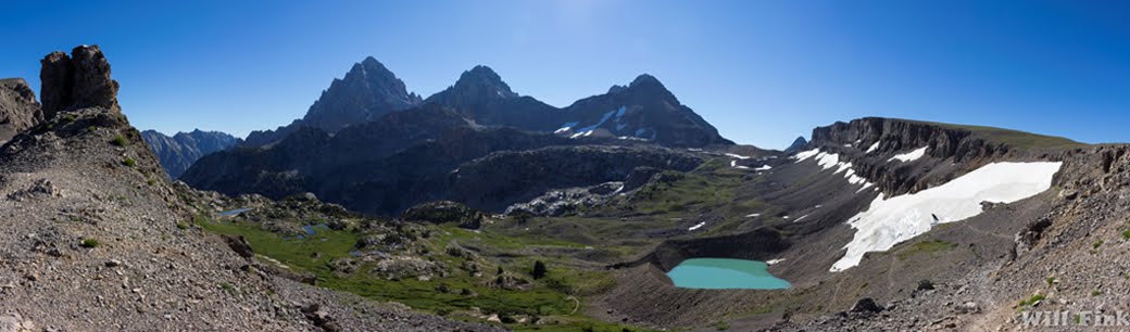
We aimed for and reached a notch that gave access to the west side of the summit and an easier approach.  More hand over hand of semi-exposed climbing came next.  But at last we were at the top! A glorious panorama spread before us, including Snowmass Lake, and Geneva lake where we had begun the day.

We snapped some shots, but with daylight already fading we didn't tarry long.  We bombed down hill - carefully - and in just a fraction of the time needed to ascend we were back with Katie, Tess, and our packs.

Next we just had to descend a thousand feet or so of nasty scree that wouldn't end.  Our knees aches and legs became rubbery.  The days labors were taking their toll.


 Eventually, we reached the bottom. And were treated to a lovely an relaxing lake side stroll.

Actually it was more of an infuriating battle against a little used and overgrown trail.  As a bonus it was muddy and slick in places, with treacherous footing throughout.

We bulled our way through, running on reserves and just wanting to reach camp before we'd be forced to switch on our headlamps.  Looking behind us, it was difficult to imagine that we had just descended that horrible looking slope.


With the last of the sun abandoning us, we reached a rushing creek fed by the lake that transformed into cascading falls.  We got out our lamps to fill up on water, and then were greeted by GQ.  Hooray, we had made it!

All of us reunited at camp, and hastily threw up shelters before settling in for dinner and exchanging the stories of the day.  Then it was off to sleep - everyone was exhausted.


Sunday morning brought clear skies, and a great view of the previous days summit.  It still looked insanely impossible to climb.

We took our time breaking camp, enjoying a relaxing breakfast.  Tessa had scrounged a tennis ball from somewhere, and a game of fetch ensued.  Hayden was soon off leash and joining in.


Sadly, Kate and Brian had to leave us.  Not having Monday off they needed to bang out 14 miles and Buckskin Pass to get back to their car.

Jimmy, Genevieve, and I wandered though the myriad campsites and trails until we also arrived at the trail to Buckskin.  We knocked it out in a few hours, passing day hikers and backpackers on the way.  I chatted with a couple that was on their way to completing a four pass loop today.


GQ and Radiance caught me, and we all descended to the intersection below for lunch by a stream. Hayden went for a swim in the bog, followed by a digging rampage in an attempt to unearth some varmint.


After a short break, we started our climb to Willow pass, which proved to be steep and challenging.  Breathing heavily, we conquered the 800ish feet to the top, and found mountain goats hanging out on a neighboring summit.  I lost my second lens cap of the trip in my haste to get my telephoto lens out.


The view below to willow lake was awesome, and devoid of a single solitary soul besides our selves.


The trail gradually descended to the lake.  Halfway down we stopped in our tracks as we heard the unmistakable howl of a wolf.  We could lay eyes on him however, and the shape of the amphitheater we were in created big echos - he (or she) was probably a long way off.  That didn't stop Hayden from responding, however.

Eventually we wound our way down to the lakeside.  Finding hammock-able trees was a challenge, and required some creative Macqyvering to obtain a suitable hang.  I think I lasso'd no less then 6 trees to hold my weight.  Jimmy and Genevieve setup there Duomid nearby.

After that, Radiance decided to take her Therma-rest for a float in the lake!  Hayden went after her, but quickly decided it was far too cold and she came bursting out.  Genevieve didn't last much longer.

During dinner, Hayden spotted some mule dear coming up the valley, which set her into an anxiety frenzy that lasted for an hour.  Eventually the long day caught up to her and she curled into a ball, fast asleep.


After dinner we had a rare opportunity to grab some star shots.  Every other night the moon had been over-powering.  With the weather forecast looking good I decided to forego the tarp to better soak them in.


Once the moon was up, it was like daylight, and I had a clear view from my Hammock all the way down the valley towards Snowmass Village.  I slept restlessly, and then slept right through my 6am alarm.  I was awoken 30 minutes later by a wet tongue - Hayden had wandered over to see if I was alive.


I grabbed a couple of hasty sunrise shots, then slammed all my gear into my pack.  I choked down a couple of snacks for breakfast, and stripped down to my hiking clothes before walking to GQ’s and Radiance’s camp spot.  Soon we were slogging back up Willow Pass, to the tune of wolves howling again.


The temperature quickly soared once we hit the sun line, and we were all feeling the lack of o2 from sleeping at 12,000 feet.  This made for a hard climb, but soon enough we reached the pass. After that it was all downhill sailing.

Once we passed the intersection for Buckskin pass, we started encountering hikers in droves - mostly day hikers, but some backpackers.  All the backpackers looked to be carrying their entire houses with them.  Ultralight methods are not the norm in Colorado!  Most of the people we passed mistook our tiny backpacks for day packs.

Hayden took glee in prancing down the trail, occasionally shooting into the brush after a squirrel or bird, but returning after a minute to jump ahead.

Once we descended all the way to Crater Lake and then Maroon Lake, the real crowds took over.  We couldn’t believe the amount of people on the trail for a Monday morning.  We hustled all the way to the TH, stopping only for a brief shots, included a victory selfie at the Maroon Bells Wilderness sign.  After one last photo op of the Maroon Bells, we reached the car and headed for town.  Seeking showers and a burger, in that order.


Sunday, October 16, 2016

Four State Challenge 2016

Every year DCUL Backpacking sends forth a group of brave and/or crazy members to attempt the 4 state challenge.  Which involves hiking the entire stretch of the AT connecting Virginia, West Virginia, Maryland and Pennsylvania - all in one day.  This adds up to 44 miles (70.8km) and 8,000 feet (2480m) of elevation gain.

It’s important to stress that this is a backpacking challenge.  All participants must carry everything they need to be self-sufficient, and they must spend the night on the trail before and after the 44 mile day.  

It’s pretty hard.  

This would be the 4th consecutive year we’ve done it as a group, though one year we actually had two runnings.

I had last tackled this event 3 years prior, setting a good time of 14 hours 36 minutes, just 3 minutes behind Beastmode and Faceplant who I hiked with for the entire stretch.  I had a mega blood-sugar crash a few miles from the finish which forced an unscheduled 10 minute break.  But I was pretty darn happy with that time.

Last year, we actually had to cancel the event due to a hurricane. Karan led the make-up event, which I couldn’t attend.  And he went total B.A.-Mode, smashing the previous record with a time of 13:26.  So this year, I went out with the goal of cracking 13 hours.  I figured this was doable based on my first experience and a slightly different strategy: going balls to the walls and not stopping for nuttin’.

The original list of ten potential attendees was whittled down to just 4 due to various reasons; including several pre-event casualties like flu and a kitchen knife incident.  In the end I set out with EZbake and Sophie Friday afternoon to set up the shuttle and bail-out cars.  Heavy D joined the event at the last minute, hopping the train directly to Harper’s Ferry from D.C..

As we shouldered our packs at the National Park gated area, we hadn’t heard from Dan yet so we hit the Lower Trail to connect to the AT, and started the climb up to Loudoun Heights.  It was much less miserable than my previous attempt, with it not being rainy and dark.  We knocked out the 2ish miles and plopped down directly on the VA/WV border.  I sent Dan a text so he’d know where to find us.  

We chatted for a few minutes until the sun dipped, then climbed into our bags to try and get a solid 8 hours of sleep before our 3am wake up call.  We had our first “Where’s Dan?” moment, but figured he was probably chowing down in Harper’s Ferry.

My cell rang an hour later as I sat reading in my hammock - it was Dan!  He had blown by our camp having missed my text.  I gave him directions then met him at the trail.  He threw down his pad and settled in for the night.

I woke up at 1am to the wind howling and branches falling.  The moon was incredibly bright, making it hard to sleep (I hadn’t bothered to put up my tarp).  After an hour of restlessness, I heard Dan stirring.  Soon everyone was up, not having any better luck with sleep.  I ate a pop-tart to get some fuel onboard.  Dan hit the trail, and the rest of us followed shortly after.  It was 2:21am.

Everyone got bogged down at the typical spot on the rocky trail.  Going up, the route is clear, but going down, there isn’t a blaze.  The path is hard to discern over the solid rock.  But I remembered vaguely that is was straight across the slab, and found the bright white blaze.

This put me in front of the group, and as I hit the 340 bridge I went full-stride.  Soon my companion’s headlamps faded behind me.  I wouldn’t see any of them again for almost 15 hours.

I got sweaty climbing the hills above Pulp Mill, then cruised through Harper’s Ferry like a ghost.  Having been through once before really helped me stay on trail.  Spotting the white blazes of the AT by headlamp can be tricky at times.

I cruised over the slick rail-bridge, and blasted out the 2.5ish miles on the C & O.  Deer and rabbits jumped away from my headlamp beam.  I pounded another 500 calories or so while the walking was easy.  The turn off the canal trail was easier to spot this time, as someone had nailed up a couple of reflectors.

Next was the un-ending climb up to Weverton Cliff; I got to the overlook about 2 hours in.  After that the climbing continued but it wasn’t as steep.  I ate spider webs continuously, and washed them down with Doritos.

I felt like I was moving pretty fast, but my footing was somewhat hampered by the occasional rock I missed with my headlamp.  I still felt like I was making good time when I rolled into Gathland State Park, where I took a 5 minute break and stepped into the bathroom.  

All was quite still in the pre-dawn darkness.  As I climbed further north my right gracilis muscle locked up, rendering that leg useless.  I did some figure-4 stretches and verbally berated it until it got back in line, then kept walking.

I was finally able to turn off my headlamp as I was on the climb up to the Washington Monument, and saw other people for the first time since the start.  At the top I refilled my two 1.5 liter Smart Water bottles and pounded a Gatorade.  It was 8:30am , 6 hours and 10 minutes in.  About 20 minutes faster than my previous running.  I ate my reward twinkie as I moved on after a 10 minute break.  20 miles down.  24 to go.

I crushed the 4ish mile descent to I-70 where Shane was waiting.  He had kindly offered to be our emergency cut-out since he had to bail from the event himself.  We chatted for a minute, though I’m not certain I said anything intelligible.  Dave and Sophie sent a text that they were at the monument.  They were making good time!  I signed the check-in sheet, and accepted some potato chip trail magic.  I inhaled them as I pressed on.

I started blowing by scores of day hikers and a few backpackers as I tried to knock out the next 10 mile section as quickly as possible.  My legs were already feeling some pain but I pushed out a fast pace.  The rocks were definitely getting to me.  I felt a few blisters I didn’t know I had explode on my toes.

By the time I rolled into Wolfsville, real pain was setting in.  I wasn’t sure my legs had enough life in them to get me to the finish in 14 hours, let alone 13.  Shane hadn’t gotten there yet.  So I plowed on with only the slightest pause to sign the check-in sheet.

I had been rolling with a 5 mph pace on most of the flats, but I just didn’t have that in me anymore.  I managed 4mph most of the time when I wasn’t climbing or stumbling over rocks.  I knocked out the first two climbs, but knew I had Raven Rock ahead of me.  I wasn’t looking forward to it at all.

I practically crawled my way up its numerous switchbacks and was ever so glad to reach the top.  It wasn’t pretty, but at least I hadn’t crashed out like last time.  My legs were feeling unreliable and weak - both screaming that they wanted to stop.

I ignored them and blasted out the next section as fast as I could - at least until I reached the rocky hell of High Rock.  Maybe I was just cranky and delirious, but following the trail proved even harder than I remembered.  There is no discernable path, and blazes are missing in key places.  Several different times I came to a complete stop next to one blaze and couldn’t find the next one.  I barely managed 1-2 mph pace through this section.  

I wasn’t able to judge time or space anymore and thought I was still several miles away from Penmar - but suddenly the rock turned to a dirt track and I rejoiced, knowing I had maybe a mile left.  I willed my legs to keep moving and slowly worked my way back up to a descent pace.

I rolled into PenMar on the last of my legs to find two weddings going on.  I walked by the first pavilion and was greeted by the smell of BBQ.  It was torture.  I briefly considered trying to scam some food.  But first I had to get to PA.

As I made the last few hundred-foot walk to the Mason-Dixon line, I realized I was just over 13 hours, and had likely beaten Karan’s time.  I found it hard to believe since I was nearly ready to lay down and die 30 minutes prior.

I checked into the mailbox register with a time of 13:15, just glad to be done - except now I had to reverse back to the park!  It took me 15 minutes.  I found Shane who dropped off a bag of snacks and Gatorade before he had to head out for work.  Then I sat around staring into space to wait for my compatriots.

Dave rolled in looking pretty fresh with a solid sub-15 hour time and a new PR.  It was also his third finish!  Another DCUL record.  Not long after Sophie also arrived, looking strong, with her first finish!

We had our second “Where’s Dan?” moment, then I went to fetch pizza from Rocky’s.

The weddings were winding down when I returned.  We watched sunset and ate.  The pizza was glorious, and I felt life returning to my body.  Eventually we wandered up the trail to see if we could spot Dan coming down.

A little past dark, we saw his headlamp bounding down the trail.  He rolled in, moving fast!  We were 4 for 4!  He signed his name in the register, securing a victory on his first attempt.  He then attacked the lukewarm pizza.

We slept the sleep of the dead that night.  The next day, we retrieved all the cars and hit Cracker Barrel for our victory breakfast.

Big thanks to Jen for helping to coordinate all the drivers, and Shane for coming out to support us.  Huge congrats to Dave, Sophie, and Dan for an epic completion of a such a challenging event! 


Notes for next time (if there is a next time!):

-Do better on the pre-hydration.
-Sport beans are king!
-Front chest feed bag worked well.  It and my ginormous hip pockets held all the food for the day.
-Gatorade for the half way point was a good idea, and a nice change from guzzling water.
-Chips and Bridgeport meats sticks broke up the sugar high nicely.
-Need more protein - some sort of chocolate milk concoction or protein shake.  Soy milk so no spoilage?
-Ham sandwich? Menu felt ok but something more substantial with protein might have helped.
-Body glide in between toes.  Rest of feet were ok. No blisters on heel or soles.
-Double headlamps, one for hips for prolonged night hiking.
-Don’t ride 110 miles the weekend before (or be getting over a crash injury).

Friday, October 7, 2016

Colorado Trip Report, Part 2 - Mt. Evans

...continuing the Colorado adventure!  If you missed it, see Part 1.

Mt. Evans in the distance.

The next morning was Monday and Katie (who had to work) generously offered me the use of her Forester for the day.  So I dropped her off at her office in the Foothills and hit I-70 west.  I decided I would tackle Mt. Evans, so I meandered my way up to Summit Lake; that put me at around 12,600 feet.  There is actually a (narrow and probably suicidal in the rain) road that goes just about to the summit, but it was closed.

Summit Lake

So I had just shy of 2,000 feet to climb in about 2.75ish miles.  I set off into the frigid howling wind, and was gasping for air in no time at all.  The route jumps almost straight up to 14,000 feet and stays there.  While I had passed any number of people on the way up, I only ever saw three others (and one dog) besides myself go above 13,000.  Clearly everyone else was smarter than us.  Even without climbing that far, you are treated to awesome views of the lake, Mt. Evans, and Chicago lakes.

Chicago Lakes

The route went right over a 13er, Mt. Spalding (which I didn’t realize at the time), and was mostly trailed.  Where the trail wasn’t obvious there were plenty of cairns to mark the way.  Eventually the route went rocky, shortly after I crossed the Evans-Spalding saddle, and I lost it a few times.  This resulted in a lot more rock scrambling than would normally be necessary when going this route, which is otherwise at worst a class 2 endeavor.  But yeah, I always need to make things more interesting.  I pretty much went up and over all the “mini-summits” en-route to the real one.

Mountain Goats!

As I traversed, I kept my eyes on an ominous bank of clouds to the west.  It was clearly storming like crazy just one ridge over, and it looked like it could potentially be coming my way.  Luckily, the wind was moving mostly north, and the worst of it peeled around my course.  I only had to contend with some snow and hail flurries carried by the very edge of the front.


After conquering all the false summits, I found the meandering path that comes up from the road and Meyer-Womble Observatory, and at last I was on top of Mt. Evans itself.  I got some photos and a quick snack.

From the Mt. Evans, looking down on Summit Lake below

I was starting to feel pretty crappy at this point.  The climb had taken almost three hours, much of that spent at 14k.  A roaring headache was coming on, and some nausea.  It was time to descend.

A new altitude PR! 14.5k feet

There is a more direct route that saves a mile directly down the northeast-face, but being solo and not feeling so hot I decided it would be wisest to retrace my steps back over mild Mt. Spalding trail.  I hauled ass, and didn't see another soul until I was nearly back at the lake almost 2 hours later.  I was fighting back the urge to vomit as I threw my pack into the Forester.


I tore through the mountain switchbacks, which are always my favorite type of driving.  Apparently they don’t believe it guardrails in Colorado!  By the time I got down to 10,000 feet, I felt 100% better.  I pounded a Gatorade for good measure.

Then it was back to Denver to pick up Katie.  That night we met up with GQ and Radiance who were crashing at a friend’s.  We hit up the local REI - the biggest I have ever seen, and got some chow.  We made our plans for the rest of the trip, and set the trail rendezvous where Katie and Brian would meet Jimmy, Genevieve, Hayden, and myself on Friday.  I slept like the dead that night.


Saturday, October 1, 2016

Colorado Trip Report, Part 1 - Crestone


Saturday morning, 9/10 I left behind the oxygen-rich sea-level air of Baltimore and boarded a plane for Denver.  I got to reunite with Katie (Sunshine Trailbreaker) who had transplanted to the Mile High City a couple of years ago.  She picked me up with her Forester, fresh from the mechanic, and we blazed a trail south out of town.  She had an ambitious plan for us to tackle a 14er.  I've certainly done dumber things, so I was all-in.

Before long, we were through the foothills and into high desert.  We made a detour on the way to satisfy the tourist requirement by checking out The Royal Gorge.  We wandered across the bridge and got snapshots of our home-state’s flag.  All fifty were represented along the railing of the bridge.


 We wanted to get a tram ride back across, but time was short and the queue was long.  We hoofed it back to the car instead, and continued south to Westcliffe.  We rolled into the nearly one-street town and stopped at Chappy’s for a late lunch/early dinner.  This was also our rendezvous with Katie's friend Brian - another recently minted Colorado local.

After stuffing our faces with burgers and mac n’ cheese we were back in Katie's Forester, with Brian on his bike following.  After 15 minutes or so the road turned to gravel, then to a dusty and rocky track.

Supposedly this is called the roughest road in Colorado!  This was Katie's first 4 wheel drive adventure, and she handled it like a champ.  Brian got sick of literally eating our dust and shot ahead, standing up in the saddle to keep control of his bike.

At one point while negotiating a particularly nasty steep climb over rocks, we ended up on three wheels!  This earned Katie a fist bump from passing Blazer and a “Go Subaru!”.

We finished our drive to the South Colony Trailhead at around 10,500 feet, slung our packs, and started climbing into the fading light.  The stars and moon were bright enough to light our way after the sun dipped below the ridge.  Eventually the trail got treacherous enough that we needed our headlamps to keep from stumbling.

We climbed steadily to somewhere above 12k feet to our camp at South Colony Lake.  I was wheezing and gasping for o2, but mostly kept up with the fleet-footed Katie and Brian.  We pitched shelters as soon as we found convenient ground, then immediately climbed into our bags as temps plummeted.

The night dipped into the low 30’s, high 20’s, and crazy wind gusts rocked the trees my hammock was anchored to.  I felt a killer migraine coming on, which I attributed to the stupidity of going from 13 feet of elevation to 12,000ish in about 12 hours, so I popped vitamin I (ibuprofen).

Soon, I started shaking uncontrollably - but wasn't cold in the slightest.  At first I thought it was another symptom of the onset of altitude sickness.  But after thinking for a few minutes, I remembered my first trip to The Tetons...Our second day in, around 10,000 feet, my buddy Peter (aka Towpath or Fiber One) had a hyponatremia attack (lack of salt or electrolytes) while we were bedded down in our shelter.  Our friend Dylan was also with us.  He produced some magic in the form of Clif Shot Bloks.  Gooey gelatin cubes packed with glucose and electrolytes.  Two hits of those and Peter was right as rain.

...I've carried Shot Bloks on every backpacking trip since.  I realized I had been pounding water all day to help cope with the jump in altitude - and barely gotten anything salty or sugary on board. From my hammock I reached into my pack until my fingers found the awesomeness that is the Mountain Berry Shot Blok.  I inhaled three and within a minute the shakes stopped.  Thanks Peter and Dylan!  Vitamin I soon had the headache under control and I was finally able to get some sleep.

I woke up to the surprisingly good sunrise (as we were surrounded by trees), and forced down some breakfast despite my lack of appetite.  Brian and Katie still slumbered.  I gave them a bit more sack time then issued a wake-up call.  No one had slept that well, and heading out into the chill morning was less than thrilling.


But before long we headed out.  We had a plan to bag either Crestone Peak or Crestone Needle - or both.  Our walk started by passing the South Colony Lakes, then immediately tackling a scree and talus field, followed by the first of the rock scrambles.


As we approached 13,000 feet - Katie remarked, “Now you'll start to feel the altitude!”  Since I was already wheezing like I had emphysema, that didn't sound good at all.  But I kept climbing gamely on legs that felt weak and squishy.


The scrambling became class four, as we decided to go after the Needle first, and then see what time and weather we had to work with.  I felt like a total slug, but the locals seemed impressed that I was there at all after learning I had only been “in country” for less than 24 hours.  I was soon getting greeted by the moniker “Sea-level” as I encountered other climbers.


I was happy just to keep my companions in sight.  Katie had become an absolute climbing beast since I had last seen her, and Brian was no slouch either.  The route was unclear at times, but for the most part easy to follow.  Still, it was nice to know I was somewhat on track by viewing other climbers above or below me.


The bulk of the climb to 14,000 feet was accomplished via a sweet sloping rock chute that offered great hand and foot holds.  It wasn't very exposed, so at most a broken hand or foot was at risk.  That wasn't enough for Brian!  So he added on a riskier off-route rock climb, but eventually rejoined us.


After conquering the chute, there was just one more short climb onto the narrow, jagged peak of Crestone Needle at 14,196 feet.  The highest altitude I had ever climbed, and my first 14er!  I took some pics while Katie and Brian made summit coffee.


Eventually I led the way back down the way I had come.  Katie and Brian got a little off-route and decided to try another way around.  So I descended the rock chute solo.  It took just as much time, if not more going down.  Also, after I saw the third death rock go flying I realized it was really dumb to have my helmet in my pack and not on my head.  I put it on and kept doing down.


Somewhere in here I ran into Katie’s friend Jason - though I didn’t realize it at the time.  He said he was looking for a lady friend of his.  I told him there were plenty of those up above me, not thinking anything of it.  As it happened he missed Katie and Brian due to their detour, and it wasn’t until we were back at town I figured out who he was.


Once I was out of the chute, I lost the route a bit.  I was always growing a little concerned about where Brian and Katie were, and expected them to pop out somewhere near where I was.  After hanging out for a little while, I decided that maybe they had been forced to descend lower down then I was.  When two other climbers came down who hadn’t seen them, I decided to get moving again.  The three of us found the route once more and kept going.

Not five minutes later, I heard my name called behind me.  Turning around, I saw my two wayward companions, and we were reunited again.  Turns out, they had hit a suicidal cliff face and been forced to retrace their steps.

We decided to make another off-route scree scramble down to Cottonwood Lake for lunch - which would also put us on the route to go after Crestone.

As we left the practically manicured section of trail, a passing climber said, “The path down to the lake is just a little ways ahead”.

To which I replied, “Yeah, but Katie likes dangerous downhill scree scrambles.”

Brian added, “We just cry and try to keep up with her.”

Then we continued our mad descent.  Both Brian and I fell on the harmless-looking green leafy plants that were in reality extremely irritating death cacti covered in millions of tiny hair-like thorns.  Well, it wouldn’t be a trip to the high-desert if I didn’t walk away with several thousand impossible-to-remove spikes stuck in my skin.

At the bottom we enjoyed a short but pleasant lunch despite the howling wind.  I was absolutely beat and was weighing whether or not I had another 14’er in me that day.  The darkening sky made our decision for us.  We had no interest in getting caught up there in a rainstorm.


So instead we started the slog back uphill.  We passed a group of longhorn sheep (maybe? goats?) as we headed for the small pass.  I don’t know what had gotten me up the Needle, but it was depleted, and I practically had to crawl my way out of there.


Thankfully the climb was short, leaving us just one more downward scramble, and then a super long and crappy scree field.  My legs were wobbly, and I missed having my trekking poles.  We lost the route again, probably the exact same spot as on the way up - but eventually hit the more obvious path leading back to South Colony Lakes.

More long horned sheep were hanging around camp, but we didn’t stay there long.  The rain was most definitely coming, so we broke camp in a hurry and hit the trail.  It was a fast and easy cruise mostly downhill.  The edge of the storm caught up to us just about 30 minutes before we got back to the trail head.  Luckily, the worst of it seemed stuck on the other side of the ridge.


Back at the vehicles, we made haste to get out of there, not relishing the idea of tackling the mess of a “road” with the added bonus of mud.  Brian went ahead of us on his bike, and got behind the wheel of Katie’s forester and took off after him.

The driving proved not to be that bad though, as we still seemed to be missing the main brunt of the storm somehow.  On the way out we even got treated to a sweet double rainbow, with the road running right down the middle of it.


After more burgers at Chappy’s, we said goodbye to Brian and hit the road back to Denver.